Imeundwa na AIImeboreshwa na watu
Riqli · hati hai · zinasasishwa kila mara
Mahali maarifa ya AI yanakutana na mazoezi ya binadamu.
Shiriki na marafiki

ATPL 033 Flight Planning & Monitoring
Hard skill.
(Aviation. Ground training. Pilot license. Fuel planning. Route planning. Performance. Self-study. Q&A. Questions Answers and explanations. Tutorials. Hard skill.)
Air Information Publications and Primary Sources
Pilots must consult primary Air Information Publications issued by national aviation authorities before every flight to obtain lasting aeronautical data. Secondary charts from commercial providers simply reproduce this authoritative content in convenient formats. The AIP is structured into GEN, ENR and AD volumes that cover location indicators, meteorological services and aerodrome details. Temporary changes appear as AIP Supplements while urgent operational updates are issued as NOTAMs of types N, R or C.
Fuel Policy and In-Flight Fuel Monitoring
Effective fuel policy requires calculating trip fuel, contingency, alternate, final reserve and additional fuel according to regulatory minima. Continuous in-flight monitoring compares actual consumption against planned figures to detect deviations early. Any unexpected increase in fuel burn triggers reassessment of remaining endurance and possible diversion decisions. Accurate fuel records also support post-flight analysis and regulatory compliance.
Nautical Air Miles and Performance Planning
Conversion between true air miles and nautical air miles accounts for wind component and is essential for accurate time and fuel estimates. Single-engine and multi-engine piston aeroplanes use specific performance graphs that incorporate density altitude, weight and configuration. These calculations determine climb gradients, cruise speeds and safe landing distances under varying conditions. Proper application prevents underestimation of required runway or fuel reserves.
Medium Range Jet Transport Flight Planning
Simplified and detailed MRJT flight planning relies on en-route climb, cruise and descent tables that integrate temperature deviations and wind data. Integrated range tables allow rapid determination of fuel required for a given distance at optimum flight levels. Additional procedures cover engine-out scenarios, drift-down and alternate selection. Accurate use of these tables ensures regulatory compliance and operational efficiency on medium-haul routes.
Point of Equal Time and Point of Safe Return
The Point of Equal Time marks the position where time to continue equals time to return, calculated from ground speeds and distances. The Point of Safe Return is the farthest point from which the aircraft can still reach a suitable alternate with required reserves. Both points are critical decision gates during long over-water or remote-area flights. Regular recalculation using updated winds keeps these points valid throughout the mission.
EASA Fuel Policy and Reserve Requirements
Under EASA Fuel Policy every flight must carry taxi fuel, trip fuel and a structured set of reserves. Contingency fuel covers deviations in consumption, weather or routing and is normally the higher of five percent of trip fuel or five minutes holding at fifteen hundred feet. Alternate fuel takes the aircraft from a missed approach to the diversion airfield while final reserve ensures a minimum thirty-minute hold for jets. Additional fuel is required only for isolated aerodromes or engine-out drift-down scenarios.
Nautical Air Miles Conversion
Nautical air miles measure the distance flown through the air at true airspeed and appear on all performance graphs for piston and jet aircraft. When a headwind exists the air distance exceeds the ground distance; a tailwind reverses the relationship. The conversion formula NAM divided by NGM equals TAS divided by ground speed allows rapid calculation on a navigation computer or by simple proportion. Accurate conversion is essential before entering climb, cruise or descent tables.
Single-engine and Multi-engine Piston Planning
Performance data for the single-engine piston aeroplane and multi-engine piston aeroplane are extracted from CAP 697 graphs that account for mass, temperature and pressure altitude. Climb tables give time, fuel and distance to a chosen flight level while cruise graphs yield true airspeed and fuel flow at selected power settings. Range and endurance figures must be corrected for wind using the nautical-air-mile relationship. These calculations form the foundation of every light-aircraft flight plan.
Medium Range Jet Transport Detailed Planning
Detailed MRJT flight planning uses integrated range tables that combine climb, cruise and descent segments for a given brake-release mass and temperature deviation. Simplified tables allow quick selection of optimum cruise altitude and Mach number under long-range or high-speed regimes. Step-climb profiles and engine-out drift-down distances are calculated separately so that fuel and time remain realistic. Computer flight-plan print-outs then list remaining fuel at every waypoint for continuous monitoring.
Point of Equal Time and Point of Safe Return
The Point of Equal Time is the position from which continuing to destination takes the same time as returning to departure, calculated from outbound and return ground speeds. The Point of Safe Return is the farthest point from which the aircraft can still reach a suitable alternate with required reserves. Both points are recalculated whenever winds or fuel state change and form critical decision gates on long over-water routes. Regular fuel checks ensure the aircraft never exceeds either limit.
Single-engine Piston Aeroplane Performance
The single-engine piston aeroplane uses CAP 697 graphs to extract climb time, fuel and nautical air miles from sea level or elevated airfields. Cruise tables for specific manifold pressure and rpm combinations yield TAS, fuel flow and range at selected pressure altitudes and ISA deviations. Range profiles include climb, cruise, taxi and a forty-five-minute reserve so the pilot can quickly choose a suitable power setting and level. Endurance figures remain independent of wind and always incorporate the required reserve.
Multi-engine Piston Aeroplane Planning
MEP climb data supply combined scales for fuel, time and distance that must be differenced when the departure airfield is above mean sea level. Range graphs distinguish between operations with a forty-five-minute reserve at forty-five percent power and no-reserve cases, then apply a one-nautical-mile correction per degree of ISA deviation. Descent tables work identically to climb tables so the net fuel, time and distance can be obtained by subtraction. Power settings of seventy-five, sixty-five and forty-five percent correspond to high-speed, economy and long-range cruise regimes.
Medium Range Jet Transport Simplified Planning
Simplified MRJT flight planning charts convert brake-release mass, trip distance, wind and landing mass into trip fuel and time for LRC, 0.74 Mach and 0.78 Mach profiles. Optimum cruise altitude is read from mass and Mach number; any deviation incurs a tabulated fuel-mileage penalty. Short-distance sectors limited by climb and descent use a separate altitude table. Additional allowances cover APU, taxi, anti-ice, high-flow packs and flaps-down manoeuvring so the final ramp fuel remains realistic.
Topographical Charts and Airways
Topographical charts display aerodrome elevations, obstacles, prohibited areas and radio navigation aids that must be cross-checked against the AIP. Airways charts provide route designators, MEAs, MOCAs and compulsory reporting points used to construct the ATC flight plan. Magnetic variation, true track and distance measurements enable accurate fuel and time calculations. Grid navigation techniques on polar charts convert true directions into grid headings for high-latitude operations.
Point of Equal Time and Point of Safe Return
The Point of Equal Time is calculated from outbound and homebound ground speeds so that time to continue equals time to return. Engine-out PET accounts for the reduced TAS after drift-down. The Point of Safe Return uses total usable fuel minus final reserve to find the farthest distance from which a suitable alternate can still be reached. Both points are recomputed whenever wind or fuel state changes and form mandatory decision gates on extended-range flights.
MRJT Detailed Flight Planning with Integrated Tables
Detailed MRJT flight planning extracts en-route climb fuel, time and nautical air miles from brake-release mass and cruise level using temperature-banded tables. Integrated range tables apply the difference principle so fuel burn equals the mass change between two cruise distances. Wind requires conversion of ground distance to still-air distance before table entry. Temperature corrections adjust both TAS and fuel flow on every page.
MRJT Descent and Additional Procedures
Descent tables give time, fuel and distance for economy or turbulent-air profiles and already include a straight-in approach. Engine anti-ice adds a fixed fifty-kilogram allowance. Computer flight plans list waypoint fuel remaining, wind components and alternate data that must be cross-checked against simplified tables. Cost-index adjustments, anti-ice and high-flow packs are applied after the basic trip fuel is obtained.
Topographical Charts and Minimum Flight Altitudes
Topographical charts display Grid MORA values that guarantee one-thousand or two-thousand-foot terrain clearance within each half-degree square. True track is measured with a protractor and converted to magnetic by applying local variation. Restricted, danger and prohibited areas must be avoided or overflown at safe levels. Semi-circular cruising levels are selected according to magnetic track for both VFR and IFR operations.
ATC Flight Plan and Airways Routing
The ATC Flight Plan records aircraft identification, equipment codes, departure and destination, route via SIDs, airways and STARs, and total estimated elapsed time. Computer print-outs already contain the completed CA48 format that ATC accepts. Alternate fuel, contingency and holding are shown separately so the commander can verify regulatory compliance. FIR boundary times and SELCAL codes complete the filing data.
Point of Equal Time and Point of Safe Return
The Point of Equal Time equates outbound and return ground speeds so time to continue equals time to return; engine-out PET incorporates the lower TAS after drift-down. The Point of Safe Return uses remaining usable fuel minus final reserve to locate the farthest point from which an alternate remains reachable. Both points are recalculated with updated winds and form mandatory decision gates on long-range sectors. Continuous fuel monitoring ensures the aircraft never exceeds either limit.
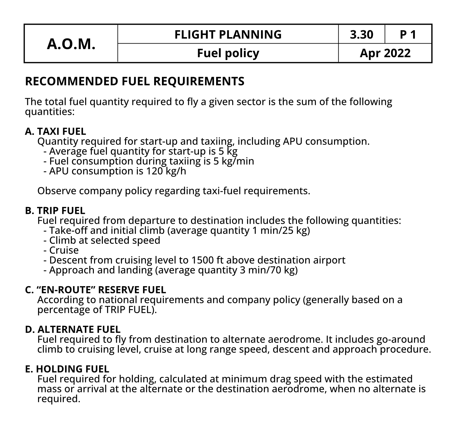
Refer to figure 033-164. Consider a commercial IFR flight. If the taxi time is 5 minutes and the APU is off, what will be the required taxi fuel?
30 kg
According to company’s fuel policy, the Taxi Fuel is the fuel quantity required for start-up and taxiing including APU consumption, where: Average fuel quantity for start-up is 5 kg. Fuel consumption during taxiing is 5 kg/min. APU consumption is 120 kg/h. From the question we have: The taxi time is 5 minutes. Since the fuel flow during taxiing is 5 kg/min, the fuel consumed during taxiing is: 5 x 5 kg = 25 kg. The APU is off ⇒ The APU consumption is 0 kg. Eventually, the required Taxi Fuel is: Taxi Fuel = 5 kg + 25 kg = 30 kg. Correct answer: 30 kg.
25 kg
40 kg
35 kg
Describe the correct meaning of the following NOTAM: SVC TEMPO TWR LOCAL CTL/CLEARANCE DELIVERY 121.0 FRI SAT 1400-2 100 1311041400-1311052100EST
Services for a temporary tower are available Friday 4th November and Saturday 5th November 2013, between 14:00 and 21:00, and frequency 121.0 will be used to control arriving and departing aircraft and for issuing clearances.
Don't for forget NOTAM time is in reference to UTC in yy/mm/dd/hh/minmin B) Date/time indicating when this NOTAM takes effect. C) Date/time specifying when the NOTAM no longer applies. SVC TEMPO TWR LOCAL CTL/CLEARANCE DELIVERY 121.0 FRI SAT 1400-2 100 1311041400-1311052100EST SVC - Services TEMPO - Temporary TWR - Tower Services for a temporary tower are available Friday 4th November and Saturday 5th November 2013, between 14:00 and 21:00, and frequency 121.0 will be used to control arriving and departing aircraft and for issuing clearances.